
How Can We Help?

Size of this preview: 484 × 600 pixels. Other resolutions: 194 × 240 pixels | 387 × 480 pixels | 994 × 1,232 pixels.
Original file (994 × 1,232 pixels, file size: 128 KB, MIME type: image/jpeg)
Captions
Captions
Add a one-line explanation of what this file represents

|
This locator map image could be re-created using vector graphics as an SVG file. This has several advantages; see Commons:Media for cleanup for more information. If an SVG form of this image is available, please upload it and afterwards replace this template with
{{vector version available|new image name}}.
It is recommended to name the SVG file “Nauru map.svg”—then the template Vector version available (or Vva) does not need the new image name parameter. |
Summary
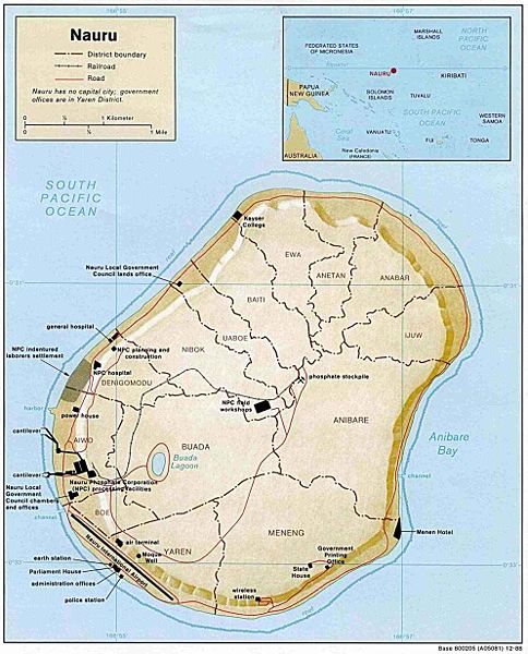
| Description | Small-label map of the island of Nauru (click image to enlarge for reading labels), northeast of Australia, north of the Solomon Islands and northwest of Fiji. The island is surrounded by a coral reef ring. The map shows some detailed contour areas near the shoreline. |
| Date | |
| Source | Nauru (Shaded Relief) 1988 from Library Map Collection: Maps of Australia and the Pacific |
| Author | U.S. Central Intelligence Agency |
| Permission (Reusing this file) |
Public domain |
| Other versions |
Same map with larger labels: Image:Nauru_map_bold.jpg (has larger labels of nearby areas, the oceans, and district names). |
Licensing
| This image is a work of a Central Intelligence Agency employee, taken or made as part of that person's official duties. As a Work of the United States Government, this image or media is in the public domain in the United States.
|

|
File history
Click on a date/time to view the file as it appeared at that time.
| Date/Time | Thumbnail | Dimensions | User | Comment | |
|---|---|---|---|---|---|
| current | 23:48, 26 March 2005 | | 994 × 1,232 (128 KB) | Jon Harald Søby (talk | contribs) | From the English Wikipedia. {{PD-USGov}} |
You cannot overwrite this file.
File usage on Commons
The following 3 pages use this file:
File usage on other wikis
The following other wikis use this file:
- Usage on azb.wikipedia.org
- Usage on bg.wikipedia.org
- Usage on en.wikipedia.org
- Usage on he.wikipedia.org
- נאורו
- תבנית:הידעת? 11 באפריל - סדרה 2
- ויקיפדיה:הידעת?/2014/יולי
- תבנית:הידעת? 11 ביולי 2014
- ויקיפדיה:הידעת?/2016/אפריל
- תבנית:הידעת? 14 באפריל 2016
- ויקיפדיה:הידעת?/2018/אפריל
- תבנית:הידעת? 10 באפריל 2018
- ויקיפדיה:הידעת?/2020/אפריל
- תבנית:הידעת? 11 באפריל 2020
- פורטל:מדע המדינה/הידעת?/קטעי הידעת?
- פורטל:מדע המדינה/הידעת?/16
- פורטל:מדעי החברה/הידעת?/קטעי הידעת?
- פורטל:מדעי החברה/הידעת?/79
- ויקיפדיה:הידעת?/2023/אפריל
- תבנית:הידעת? 11 באפריל 2023
- Usage on id.wikipedia.org
- Usage on incubator.wikimedia.org
- Usage on ja.wikipedia.org
- Usage on jv.wikipedia.org
- Usage on ka.wikipedia.org
- Usage on ms.wikipedia.org
- Usage on sv.wikipedia.org
- Usage on uk.wikipedia.org

Recent Comments