
How Can We Help?

Size of this JPG preview of this PDF file: 800 × 535 pixels. Other resolutions: 320 × 214 pixels | 640 × 428 pixels | 1,024 × 684 pixels | 1,280 × 855 pixels | 2,472 × 1,652 pixels.
Original file (2,472 × 1,652 pixels, file size: 61.4 MB, MIME type: application/pdf)
Captions
Captions
Map from 1900 US census showing the westward moving frontier line.
Summary
| Description |
English: This map shows the population distribution of the 45 states and 4 territories of the mainland United States and the extent of the frontier line by 1900. |
| Date | |
| Source | United States. Bureau of the Census. Statistical Atlas of the United States, 1910 , 1914, https://fraser.stlouisfed.org/title/74, accessed on January 7, 2020. |
| Author | United States Census Bureau |
Licensing
This image or file is a work of a United States Census Bureau employee, taken or made as part of that person's official duties. As a work of the U.S. federal government, the image is in the public domain.
|
 |
File history
Click on a date/time to view the file as it appeared at that time.
| Date/Time | Thumbnail | Dimensions | User | Comment | |
|---|---|---|---|---|---|
| current | 20:18, 7 January 2020 | 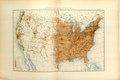 | 2,472 × 1,652 (61.4 MB) | Killroy is here (talk | contribs) | User created page with UploadWizard |
You cannot overwrite this file.
File usage on Commons
There are no pages that use this file.
File usage on other wikis
The following other wikis use this file:
- Usage on en.wikipedia.org
- Usage on hu.wikipedia.org

Recent Comments