
How Can We Help?
No higher resolution available.
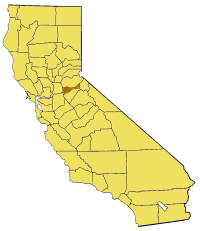
California_map_showing_Amador_County.png (200 × 231 pixels, file size: 22 KB, MIME type: image/png)
Captions
Captions
Add a one-line explanation of what this file represents
Map of Amador county in California. From en:

|
Permission is granted to copy, distribute and/or modify this document under the terms of the GNU Free Documentation License, Version 1.2 or any later version published by the Free Software Foundation; with no Invariant Sections, no Front-Cover Texts, and no Back-Cover Texts. A copy of the license is included in the section entitled GNU Free Documentation License. |
| This file is licensed under the Creative Commons Attribution-Share Alike 3.0 Unported license. | ||
| ||
| This licensing tag was added to this file as part of the GFDL licensing update. |
File history
Click on a date/time to view the file as it appeared at that time.
| Date/Time | Thumbnail | Dimensions | User | Comment | |
|---|---|---|---|---|---|
| current | 16:53, 1 July 2005 | | 200 × 231 (22 KB) | Pyramide~commonswiki (talk | contribs) | Map of Amador county in California. From en: {{GFDL}} Category:Maps of counties in California |
You cannot overwrite this file.
File usage on Commons
The following page uses this file:
File usage on other wikis
The following other wikis use this file:
- Usage on bg.wikipedia.org
- Usage on en.wikipedia.org
- Lancha Plana, California
- Bear River (Mokelumne River tributary)
- Amador County Arts Council
- Template:AmadorCountyCA-geo-stub
- Jackson Creek (Dry Creek tributary)
- Thunder Mountain (Amador County, California)
- Cooks Station
- Enterprise, Amador County, California
- Carbondale, California
- Clinton, California
- Forest Home, California
- Irishtown, California
- Lower Rancheria, California
- May, California
- New Chicago, California
- Pine Acres, California
- Sutter Hill, California
- Yeomet, California
- Fort Ann, California
- Camp O'pera, California
- Mount Zion Demonstration State Forest
- Lake Amador
- Mokelumne Peak
- Amador County Superior Court
- Amador Pines, California
- Lockwood, Amador County, California
- Usage on li.wikipedia.org
- Usage on www.wikidata.org

Recent Comments