
Bih_IEBLinRed.png (329 × 352 pixels, file size: 23 KB, MIME type: image/png)
Captions
Captions
Summary

|
This historical map image could be re-created using vector graphics as an SVG file. This has several advantages; see Commons:Media for cleanup for more information. If an SVG form of this image is available, please upload it and afterwards replace this template with
{{vector version available|new image name}}.
It is recommended to name the SVG file “Bih IEBLinRed.svg”—then the template Vector version available (or Vva) does not need the new image name parameter. |
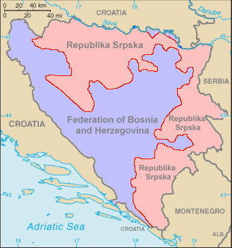
This is a map of Bosnia-Herzegovina (from the World Factbook archive copy at the Wayback Machine) with the Inter-Entity Boundary Line (IEBL) in red. The map has been made simpler by removing the names of the cities, leaving only the two entities. Color has added for the entities as well. The labels have also been redone, since they did not show up well against the colors. This map is based off the one in the World Factbook as mirrored by the PCL.
Licensing
Ovo je ispravna karta .Zaboravili ste Brcko district je posebna jedinica koje ne pripada nikome a nije oznaceno[1]
This image is in the public domain because it contains materials that originally came from the United States Central Intelligence Agency's World Factbook.
|
 |
File history
Click on a date/time to view the file as it appeared at that time.
| Date/Time | Thumbnail | Dimensions | User | Comment | |
|---|---|---|---|---|---|
| current | 05:17, 29 October 2006 | | 329 × 352 (23 KB) | Hoshie (talk | contribs) | This is a map of Bosnia-Herzegovina (from the [https://www.cia.gov/cia/publications/factbook/maps/bk-map.gif World Factbook]) with the Inter-Entity Boundary Line (IEBL) in red. The map has been made simpler by removing the |
You cannot overwrite this file.
File usage on Commons
The following 3 pages use this file:
File usage on other wikis
The following other wikis use this file:
- Usage on de.wikipedia.org
- Usage on sr.wikipedia.org
- Usage on vec.wikipedia.org

![[1]](http://3.bp.blogspot.com/-I8wsRh6MpT4/UPRnAon0eYI/AAAAAAAAAFI/7NnMbKQExvg/s1600/Federalna+struktura+BiH.jpg)
Recent Comments