
How Can We Help?
| Object location | | View all coordinates using: OpenStreetMap |
|---|
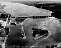
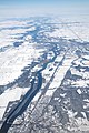
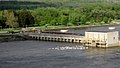
English: Starved Rock Lock and Dam, a lock and dam on the Illinois River near Starved Rock State Park in LaSalle County, Illinois, 483 feet (147 m) above sea level and 231 miles (372 km) upstream from the Mississippi River.
| Illinois River locks | ||||
|---|---|---|---|---|
| downstream: Peoria Lock and Dam |
← | Starved Rock Lock and Dam (231 miles or 372 kilometers) from Mississippi River) |
← | upstream: Marseilles Lock and Dam |
Subcategories
This category has the following 2 subcategories, out of 2 total.
Media in category "Starved Rock Lock and Dam"
The following 22 files are in this category, out of 22 total.
-
 Dam near Starved Rock State Park, Illinois River.jpg 3,906 × 2,602; 6.63 MB
-
 Gfp-illinois-starved-rock-state-park-across-the-dam.jpg 2,500 × 1,667; 475 KB
-
 Gfp-illinois-starved-rock-state-park-dam-view.jpg 2,500 × 1,667; 403 KB
-
 Illinois - Starved Rock through Trenton - NARA - 23939963 (cropped).jpg 3,444 × 2,721; 2.52 MB
-
 Illinois - Starved Rock through Trenton - NARA - 23939963.jpg 4,385 × 3,382; 2.94 MB
-
 Illinois River aerial.jpg 2,912 × 4,368; 5.68 MB
-
 Illinois River Dam - panoramio.jpg 3,456 × 5,184; 4.19 MB
-
 Illinois River, seen from Starved Rock.jpg 864 × 1,152; 166 KB
-
 Lock and dam closeup opposite starved rock IL.JPG 3,072 × 2,304; 3.1 MB
-
 Lock and Dam closeup starved rock.JPG 3,072 × 2,304; 3 MB
-
 Lock and dam starved rock.JPG 3,072 × 2,304; 2.76 MB
-

-

-
 Starved Rock Lock & Dam (8755675138).jpg 2,862 × 1,612; 1.69 MB
-
 Starved Rock Lock & Dam.jpg 960 × 720; 105 KB
-
 Starved Rock Lock (COE) tow downbound.jpg 800 × 600; 85 KB
-
 Starved Rock Lock and Dam - panoramio.jpg 3,872 × 2,592; 4.4 MB
-
 Starved Rock Lock and Dam.JPG 2,304 × 1,728; 798 KB
-
 Starved Rock State Park 6.jpg 4,368 × 2,912; 5.93 MB
-
 Starved Rock State Park 7.jpg 4,368 × 2,912; 4.65 MB
-
 USACE Starved Rock Lock and Dam.jpg 1,500 × 1,000; 304 KB
-
 View upstream from Starved Rock.jpg 4,016 × 3,008; 5.08 MB


Recent Comments