
How Can We Help?
Media in category "Maps of Upper Silesia Province"
The following 21 files are in this category, out of 21 total.
-
 Uebersichtskarte des Grossdeutschen Reiches 1943.jpg 3,012 × 2,699; 3.33 MB
-
 Aeberschläsing, Landkreese 1927 - 1938.png 1,565 × 1,235; 281 KB
-
 Area of German Silesia claimed by Czechoslovakia February 1919.png 5,128 × 2,370; 10.6 MB
-
 Former eastern territories of Germany - East Upper Silesia.png 322 × 368; 6 KB
-
 Górny Śląsk mapa.png 982 × 918; 144 KB
-
 Księstwo Opolskie za Jana II Dobrego a Prowincja Górny Śląsk.png 1,792 × 1,744; 44 KB
-
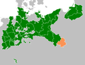
 Location Nazi Germany - Upper Silesia.png 806 × 766; 53 KB
-
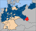 Map-Prussia-UpperSilesia.svg 1,185 × 1,007; 591 KB
-
 Mapy i plany 20625 Fotopolska-Eu (1)-Śląsk Bytomski na Górnym Śląsku.jpg 1,200 × 799; 444 KB
-
 Oberschlesien 1921 Voten.png 411 × 323; 13 KB
-
 Oberschlesien 1921.png 411 × 323; 13 KB
-
 Oberschlesien, Oppeln Locator map.png 900 × 847; 94 KB
-
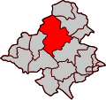 Province of Upper Silesia, Landkreis Oppeln.svg 795 × 745; 127 KB
-
 OSlez1922.png 1,307 × 987; 44 KB
-
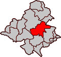
 Province of Upper Silesia, Landkreis Cosel.svg 795 × 746; 114 KB
-
 Province of Upper Silesia, Landkreis Falkenberg O.S.svg 795 × 745; 130 KB
-
 Province of Upper Silesia, Landkreis Groß Strehlitz.svg 795 × 746; 109 KB
-
 Province of Upper Silesia, Landkreis Neisse.svg 795 × 745; 130 KB
-
 Province of Upper Silesia, Landkreis Neustadt O.S.svg 795 × 745; 130 KB
-
 Teilung Oberschlesiens.png 225 × 435; 23 KB
-
 Weimar Republic - Prussia - Upper Silesia (1925).svg 976 × 818; 697 KB


Recent Comments