Introduction Peru, officially the Republic of Peru, is a country in western South America. It is bordered in the north by Ecuador and Colombia, in the east by Brazil, in the southeast by Bolivia, in the south by Chile, and in the south and west by the Pacific Ocean. Peru is a megadiverse country with habitats ranging from the arid plains of the Pacific coastal region in the west to the peaks of the Andes mountains extending from the north to the southeast of the country to the tropical Amazon basin rainforest in the east with the Amazon River. Peru has a population of over 32 million, and its capital and largest city is Lima. At 1,285,216 km2 (496,225 sq mi), Peru is the 19th largest country in the world, and the third largest in South America. Peruvian territory was home to several cultures during the ancient and medieval periods, and has one of the longest histories of civilization of any country, tracing its heritage back to the 10th millennium BCE. Notable pre-colonial cultures and civilizations include the Caral–Supe civilization (the earliest civilization in the Americas and considered one of the cradles of civilization), the Nazca culture, the Wari and Tiwanaku empires, the Kingdom of Cusco, and the Inca Empire, the largest known state in the pre-Columbian Americas. The Spanish Empire conquered the region in the 16th century and Charles V established a viceroyalty with the official name of the Kingdom of Peru that encompassed most of its South American territories, with its capital in Lima. Higher education started in the Americas with the official establishment of the National University of San Marcos in Lima in 1551. Peru's population includes Mestizos, Amerindians, Europeans, Africans and Asians. The main spoken language is Spanish, although a significant number of Peruvians speak Quechuan languages, Aymara, or other Indigenous languages. This mixture of cultural traditions has resulted in a wide diversity of expressions in fields such as art, cuisine, literature, and music. (Full article...) Entries here consist of Good and Featured articles, which meet a core set of high editorial standards.
Ubinas is an active stratovolcano in the Moquegua Region of southern Peru, approximately 60 kilometres (37 mi) east of the city of Arequipa. Part of the Central Volcanic Zone of the Andes, it rises 5,672 metres (18,609 ft) above sea level. The volcano's summit is cut by a 1.4-kilometre-wide (0.87 mi) and 150-metre-deep (490 ft) caldera, which itself contains a smaller crater. Below the summit, Ubinas has the shape of an upwards-steepening cone with a prominent notch on the southern side. The gently sloping lower part of the volcano is also known as Ubinas I and the steeper upper part as Ubinas II; they represent different stages in the volcano's geological history. The most active volcano in Peru, Ubinas has a history of small to moderate explosive eruptions as well as a few larger eruptions, such as in 1667, along with persistent degassing and ash emissions. Activity at the volcano began in the Pleistocene epoch, and led to the growth of the current mountain in two phases. Among the recent eruptions was the 2006–2007 event, which produced eruption columns and led to ash fall in the region, resulting in health issues and evacuations. During the most recent activity, from 2013 to 2017, a lava flow formed inside the crater, and further ash falls led to renewed evacuations of surrounding towns. Ubinas is monitored by the Peruvian geological service INGEMMET, which has published a volcano hazard map for Ubinas and regular volcanic activity reports. (Full article...)Selected image Photo credit: Ericbronder
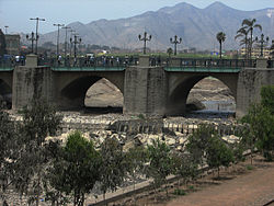
The Rímac River runs through the Peruvian capital of Lima and is the city's main source of water. One of the oldest bridges spanning the river is the Puente de Piedra (Stone Bridge) built out in stone masonry in the early 17th century. The bridge is still in use and connects the two districts that comprise the Historic Center of Lima: Rímac and Lima Cercado. (more...) Selected battleThe Battle of Miraflores occurred on January 15, 1881 in the Miraflores District of Lima, Peru. It was an important battle during the War of the Pacific that was fought between Chile and the forces of Peru. The Chilean army led by Gen. Manuel Baquedano defeated the army commanded by Nicolás de Pierola guarding the second defensive line of the Peruvian capital city. Two days later, Lima, the capital city of Peru was occupied by Chilean troops. Gen. Baquedano's forces marched into Lima triumphant, while Peru's president and his officers fled into the interior, leaving the country without any government. Although the fall of Lima, the war continued between the occupation army and the troops of Andres Caceres for another three years. During the occupation of Lima, Peru's National Library was set on flames, while a number of other monuments were ransacked by Chilean forces and taken as war trophies. (more...) In this month
General imagesThe following are images from various Peru-related articles on Wikipedia.
Selected article -Water resources and irrigation infrastructure in Peru vary throughout the country. The coastal region, an arid but fertile land, has about two-thirds of Peru’s irrigation infrastructure due to private and public investment aimed at increasing agricultural exports. The Highlands and Amazon regions, with abundant water resources but rudimentary irrigation systems, are home to the majority of Peru's poor, many of whom rely on subsistence or small-scale farming. The Peruvian Government is undertaking several programs aimed at addressing key challenges in the irrigation sector like increasing water stress, competing interests, deteriorating water quality, poor efficiency of irrigation, drainage systems (including low technology systems and underutilization of existing infrastructure), weak institutional and legal frameworks, low cost recovery (i.e., operation and maintenance costs above actual collections), and vulnerability to climate variability and change, including extreme weather conditions and glacier retreat. (Full article...)Did you know (auto-generated) -
CategoriesRelated portalsSelected quote -
English art historian, writer, antiquarian and politician Horace Walpole 1717–1797
Basic facts & figuresMore did you know...
Peru TopicsRecognized contentFeatured articlesFeatured listsGood articles
WikiProjectsThings you can do
New articlesThis list was generated from these rules. Questions and feedback are always welcome! The search is being run daily with the most recent ~14 days of results. Note: Some articles may not be relevant to this project.
Rules | Match log | Results page (for watching) | Last updated: 2024-07-04 21:25 (UTC) Note: The list display can now be customized by each user. See List display personalization for details.
Associated WikimediaThe following Wikimedia Foundation sister projects provide more on this subject:
Discover Wikipedia using portals |
How Can We Help?


Recent Comments