
How Can We Help?

Size of this preview: 800 × 528 pixels. Other resolutions: 320 × 211 pixels | 640 × 423 pixels | 1,024 × 676 pixels | 1,280 × 846 pixels | 2,560 × 1,691 pixels | 3,391 × 2,240 pixels.
Original file (3,391 × 2,240 pixels, file size: 2.07 MB, MIME type: image/jpeg)
This is a photo of listed building number 1333613. |
Summary
| Description |
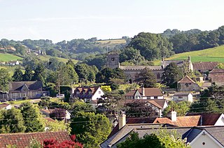
English: Roofscape of Uplyme, Devon, looking north to the parish church of SS Peter and Paul |
| Date | |
| Source | From geograph.org.uk |
| Author | Philip Pankhurst |
| Permission (Reusing this file) |
Creative Commons Attribution Share-alike license 2.0 |
| Attribution (required by the license) | Philip Pankhurst / Uplyme village / |
| Camera location | | View this and other nearby images on: OpenStreetMap |
|---|
| Object location | | View this and other nearby images on: OpenStreetMap |
|---|
Licensing

|
This image was taken from the Geograph project collection. See this photograph's page on the Geograph website for the photographer's contact details. The copyright on this image is owned by Philip Pankhurst and is licensed for reuse under the Creative Commons Attribution-ShareAlike 2.0 license.
|
This file is licensed under the Creative Commons Attribution-Share Alike 2.0 Generic license.
Attribution: Philip Pankhurst
- You are free:
- to share – to copy, distribute and transmit the work
- to remix – to adapt the work
- Under the following conditions:
- attribution – You must give appropriate credit, provide a link to the license, and indicate if changes were made. You may do so in any reasonable manner, but not in any way that suggests the licensor endorses you or your use.
- share alike – If you remix, transform, or build upon the material, you must distribute your contributions under the same or compatible license as the original.
File history
Click on a date/time to view the file as it appeared at that time.
| Date/Time | Thumbnail | Dimensions | User | Comment | |
|---|---|---|---|---|---|
| current | 21:33, 9 June 2014 | | 3,391 × 2,240 (2.07 MB) | File Upload Bot (Magnus Manske) | Transferred from Geograph by User:plucas58 |
File usage
The following pages on the English Wikipedia use this file (pages on other projects are not listed):
Global file usage
The following other wikis use this file:

.jpg¶ms=050.734019_N_-002.958551_E_globe:Earth_type:camera_heading:0.00_source:geograph&language=en)
.jpg¶ms=050.737220_N_-002.958100_E_globe:Earth_class:object_type:object_source:geograph-osgb36(SY32489350)_region:GB-GBN_heading:0.00&language=en)
Recent Comments