The Blue Marble, a photograph of the planet Earth made on 7 December 1972 by the crew of the Apollo 17 spacecraft.
The world is the totality of entities, the whole of reality, or everything that exists. The nature of the world has been conceptualized differently in different fields. Some conceptions see the world as unique while others talk of a "plurality of worlds". Some treat the world as one simple object while others analyze the world as a complex made up of parts.
In scientific cosmology, the world or universe is commonly defined as "[t]he totality of all space and time; all that is, has been, and will be". Theories of modality talk of possible worlds as complete and consistent ways how things could have been. Phenomenology, starting from the horizon of co-given objects present in the periphery of every experience, defines the world as the biggest horizon or the "horizon of all horizons". In philosophy of mind, the world is contrasted with the mind as that which is represented by the mind. Theology conceptualizes the world in relation to God, for example, as God's creation, as identical to God or as the two being interdependent. In religions, there is a tendency to downgrade the material or sensory world in favor of a spiritual world to be sought through religious practice. A comprehensive representation of the world and our place in it, as is found in religions, is known as a worldview. Cosmogony is the field that studies the origin or creation of the world while eschatology refers to the science or doctrine of the last things or of the end of the world.
Public interest in space travel originated in the 1951 publication of a Soviet youth magazine and was promptly picked up by US magazines. The competition began on July 30, 1955, when the United States announced its intent to launch artificial satellites for the International Geophysical Year. Four days later, the Soviet Union responded by declaring they would also launch a satellite "in the near future". The launching of satellites was enabled by developments in ballistic missile capabilities since the end of World War II. The competition gained Western public attention with the "Sputnik crisis", when the USSR achieved the first successful satellite launch, Sputnik 1, on October 4, 1957. It gained momentum when the USSR sent the first human, Yuri Gagarin, into space with the orbital flight of Vostok 1 on April 12, 1961. These were followed by a string of other early firsts achieved by the Soviets over the next few years. (Full article...)
Image 3
Sand and dunes of the Libyan Desert A desert is a landscape where little precipitation occurs and, consequently, living conditions create unique biomes and ecosystems. The lack of vegetation exposes the unprotected surface of the ground to denudation. About one-third of the land surface of the Earth is arid or semi-arid. This includes much of the polar regions, where little precipitation occurs, and which are sometimes called polar deserts or "cold deserts". Deserts can be classified by the amount of precipitation that falls, by the temperature that prevails, by the causes of desertification or by their geographical location.
Deserts are formed by weathering processes as large variations in temperature between day and night put strains on the rocks, which consequently break in pieces. Although rain seldom occurs in deserts, there are occasional downpours that can result in flash floods. Rain falling on hot rocks can cause them to shatter, and the resulting fragments and rubble strewn over the desert floor are further eroded by the wind. This picks up particles of sand and dust, which can remain airborne for extended periods – sometimes causing the formation of sand storms or dust storms. Wind-blown sand grains striking any solid object in their path can abrade the surface. Rocks are smoothed down, and the wind sorts sand into uniform deposits. The grains end up as level sheets of sand or are piled high in billowing sand dunes. Other deserts are flat, stony plains where all the fine material has been blown away and the surface consists of a mosaic of smooth stones, often forming desert pavements, and little further erosion takes place. Other desert features include rock outcrops, exposed bedrock and clays once deposited by flowing water. Temporary lakes may form and salt pans may be left when waters evaporate. There may be underground sources of water, in the form of springs and seepages from aquifers. Where these are found, oases can occur. (Full article...)
Image 4
Least developed countries (designated by the UN as of 2023)
A country is classified among the Least Developed Countries if it meets three criteria:
Poverty – adjustable criterion based on Gross national income (GNI) per capita averaged over three years. As of 2018, a country must have GNI per capita less than US$1,025 to be included on the list, and over $1,230 to graduate from it.
Economic vulnerability (based on instability of agricultural production, instability of exports of goods and services, economic importance of non-traditional activities, merchandise export concentration, handicap of economic smallness, and the percentage of population displaced by natural disasters).
The Webb Ellis Cup, awarded to the winner of men's Rugby World Cup.
The Rugby World Cup is a men's rugby union tournament contested every four years between the top international teams, the winners of which are recognised as the World champions of the sport.
The tournament is administered by World Rugby, the sport's international governing body. The winners are awarded the Webb Ellis Cup, named after William Webb Ellis who, according to a popular legend, invented rugby by picking up the ball during a football game and running with it. (Full article...)
Image 6
Non-UN member states recognised by at least one UN member state
Non-UN member states recognised only by other non-UN member states
Earth's history with time-spans of the eons to scale The history of Earth concerns the development of planetEarth from its formation to the present day. Nearly all branches of natural science have contributed to understanding of the main events of Earth's past, characterized by constant geological change and biological evolution.
The geological time scale (GTS), as defined by international convention, depicts the large spans of time from the beginning of the Earth to the present, and its divisions chronicle some definitive events of Earth history. (In the graphic, Ma means "million years ago".) Earth formed around 4.54 billion years ago, approximately one-third the age of the universe, by accretion from the solar nebula. Volcanic outgassing probably created the primordial atmosphere and then the ocean, but the early atmosphere contained almost no oxygen. Much of the Earth was molten because of frequent collisions with other bodies which led to extreme volcanism. While the Earth was in its earliest stage (Early Earth), a giant impact collision with a planet-sized body named Theia is thought to have formed the Moon. Over time, the Earth cooled, causing the formation of a solid crust, and allowing liquid water on the surface. In June 2023, scientists reported evidence that the planet Earth may have formed in just three million years, much faster than the 10−100 million years thought earlier. (Full article...)
Image 2Change in average surface air temperature and drivers for that change. Human activity has caused increased temperatures, with natural forces adding some variability. (from Earth)
Image 9An animation of the changing density of productive vegetation on land (low in brown; heavy in dark green) and phytoplankton at the ocean surface (low in purple; high in yellow) (from Earth)
Image 18Artist's impression of a Hadean landscape with the relatively newly formed Moon still looming closely over Earth and both bodies sustaining strong volcanism. (from History of Earth)
Image 23A reconstruction of human history based on fossil data. (from History of Earth)
Image 24A reconstruction of Pannotia (550 Ma). (from History of Earth)
Image 25The replicator in virtually all known life is deoxyribonucleic acid. DNA is far more complex than the original replicator and its replication systems are highly elaborate. (from History of Earth)
Image 28Trilobites first appeared during the Cambrian period and were among the most widespread and diverse groups of Paleozoic organisms. (from History of Earth)
Image 29Pangaea was a supercontinent that existed from about 300 to 180 Ma. The outlines of the modern continents and other landmasses are indicated on this map. (from History of Earth)
Image 40An artist's impression of the Archean, the eon after Earth's formation, featuring round stromatolites, which are early oxygen-producing forms of life from billions of years ago. After the Late Heavy Bombardment, Earth's crust had cooled, its water-rich barren surface is marked by continents and volcanoes, with the Moon still orbiting Earth half as far as it is today, appearing 2.8 times larger and producing strong tides. (from Earth)
Image 42Tiktaalik, a fish with limb-like fins and a predecessor of tetrapods. Reconstruction from fossils about 375 million years old. (from History of Earth)
Image 47Geologic map of North America, color-coded by age. From most recent to oldest, age is indicated by yellow, green, blue, and red. The reds and pinks indicate rock from the Archean.
Image 49A map of heat flow from Earth's interior to the surface of Earth's crust, mostly along the oceanic ridges (from Earth)
Image 50A view of Earth with its global ocean and cloud cover, which dominate Earth's surface and hydrosphere; at Earth's polar regions, its hydrosphere forms larger areas of ice cover. (from Earth)
Image 63Artist's impression of Earth during the later Archean, the largely cooled planetary crust and water-rich barren surface, marked by volcanoes and continents, features already roundmicrobialites. The Moon, still orbiting Earth much closer than today and still dominating Earth's sky, produced strong tides. (from History of Earth)
Image 66A 2012 artistic impression of the early Solar System's protoplanetary disk from which Earth and other Solar System bodies were formed (from Earth)
Image 74Earth's night-side upper atmosphere appearing from the bottom as bands of afterglow illuminating the troposphere in orange with silhouettes of clouds, and the stratosphere in white and blue. Next the mesosphere (pink area) extends to the orange and faintly green line of the lowest airglow, at about one hundred kilometers at the edge of space and the lower edge of the thermosphere (invisible). Continuing with green and red bands of aurorae stretching over several hundred kilometers. (from Earth)
Image 75Artist's rendition of an oxinated fully-frozen Snowball Earth with no remaining liquid surface water. (from History of Earth)
Image 80Artist's impression of the enormous collision that probably formed the Moon (from History of Earth)
Image 81Exaggerated illustration of Earth's elliptical orbit around the Sun, marking that the orbital extreme points (apoapsis and periapsis) are not the same as the four seasonal extreme points, the equinox and solstice (from Earth)
Image 82Earth's western hemisphere showing topography relative to Earth's center instead of to mean sea level, as in common topographic maps (from Earth)
Image 83Pillar erected by India's Maurya Emperor Ashoka
Image 84Earth's history with time-spans of the eons to scale (from History of Earth)
Manila (/məˈnɪlə/mə-NIL-ə; Filipino: Maynila, pronounced[majˈnilaʔ]), officially the City of Manila (Filipino: Lungsod ng Maynila, [luŋˈsodnɐŋmajˈnilaʔ]), is the capital and second-most-populous city of the Philippines after Quezon City. Located on the eastern shore of Manila Bay on the island of Luzon, it is classified as a highly urbanized city. As of 2019, it is the world's most densely populated city proper. It was the first chartered city in the country, and was designated as such by the Philippine Commission Act No. 183 on July 31, 1901. It became autonomous with the passage of Republic Act No. 409, "The Revised Charter of the City of Manila", on June 18, 1949. Manila is considered to be part of the world's original set of global cities because its commercial networks were the first to extend across the Pacific Ocean and connect Asia with the Spanish Americas through the galleon trade; when this was accomplished, it was the first time an uninterrupted chain of trade routes circling the planet had been established.
... that Sherita Hill Golden demonstrated that diabetics were more likely to develop depression and that those with depression were more likely to become diabetic?
... that some British soldiers hung the First World War propaganda poster "Daddy, what did you do in the Great War?" in the trenches and left sarcastic answers to the daughter's question?
... that at the time of its construction in 1920, the Howard Theatre in Atlanta was the second-largest movie theater in the world, with a seating capacity of 2,700?
... that undercover journalists at the Greenpeace publication Unearthed tricked an ExxonMobil lobbyist into revealing the company's agenda by posing as job recruiters?
The Seven Wonders of the Ancient World, also known as the Seven Wonders of the World or simply the Seven Wonders, is a list of seven notable structures present during classical antiquity. The first known list of seven wonders dates back to the 2nd–1st century BC.
While the entries have varied over the centuries, the seven traditional wonders are the Great Pyramid of Giza, the Colossus of Rhodes, the Lighthouse of Alexandria, the Mausoleum at Halicarnassus, the Temple of Artemis, the Statue of Zeus at Olympia, and the Hanging Gardens of Babylon. Using modern-day countries, two of the wonders were located in Greece, two in Turkey, two in Egypt, and one in Iraq. Of the seven wonders, only the Pyramid of Giza, which is also by far the oldest of the wonders, still remains standing, while the others have been destroyed over the centuries. There is scholarly debate over the exact nature of the Hanging Gardens, and there is doubt as to whether they existed at all. (Full article...)
The state of Johor in Malaysia is noted for its national parks and forest reserves which preserve virgin rainforests known for its biodiversity and endangered species of animals. Mangrove swamps and coral reefs are also protected within these parks. (Full article...)
Strict nature reserve — Area of unmodified natural features with representative ecosystems set aside for the preservation of its biodiversity and for scientific research and monitoring.
Special nature reserve — Area of unmodified or slightly modified natural features of great importance due to uniqueness and rarity which includes the habitats of endangered species set aside for the preservation of its unique features, education, limited tourism and for scientific research and monitoring.
National park — Area with large number of diverse ecosystems of national value, with outstanding natural features and/or cultural heritage set aside for the preservation of its natural resources and for educational, scientific and tourist use.
Natural monument — Small unmodified or slightly modified natural feature, object or phenomenon, easily detectable and unique, with unique natural attributes.
Protected habitat — Area which includes habitats of one or more wildlife species.
Landscape of outstanding features — Area of remarkable appearance with important natural and cultural value.
Nature park — Area of well-preserved natural values with preserved natural ecosystems and picturesque landscape set aside for the preservation of biodiversity and for educational, tourist, recreational and scientific use.
The protected areas of Michigan come in an array of different types and levels of protection. Michigan has five units of the National Park Service system. There are 14 federal wilderness areas; the majority of these are also tribal-designated wildernesses. It has one of the largest state forest systems as well having four national forests. The state maintains a large state park system and there are also regional parks, and county, township and city parks. Still other parks on land and in the Great Lakes are maintained by other governmental bodies. Private protected areas also exist in the state, mainly lands owned by land conservancies. (Full article...)
Image 8
Part of the Brecon Beacons National Park, looking from the highest point of Pen y Fan (886 m/2907 feet) to Cribyn (795 m/2608 feet). Protected areas of the United Kingdom are areas in the United Kingdom which need and /or receive protection because of their environmental, historical or cultural value to the nation. Methods and aims of protection vary depending on the nature and importance of the resource. Protection operates at local, regional, national and international levels, and may be backed by legislation and international treaty, or less formally by planning policy.
Within the United Kingdom, different approaches are taken to some forms of protection within the constituent countries of England, Scotland, Wales and Northern Ireland, while other forms of protection are more consistent across the UK. Protected areas can be divided according to the type of resource which each seeks to protect. Primarily, these are: scenic or landscape value; biodiversity value (species and habitats); geodiversity value (relating to geology and geomorphology); and cultural or historic value. Several types of protected areas are focused on more than one of these areas. (Full article...)
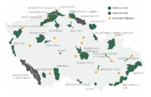
Map of protected areas of the Czech Republic: national parks (grey) and protected landscape areas (green) There are several types of protected areas of the Czech Republic. The main form of landscape protection is delimitation of special protected areas. All the types of protected areas are determined by law. (Full article...)
Andohahela National Park in southern Madagascar The national parks of Madagascar include all officially recognized protected areas as of 2015. The protected areas network of Madagascar is managed by the Madagascar National Parks Association (PNM-ANGAP). The network includes three types of protected areas: Strict Nature Reserves (IUCN category Ia), National Parks (IUCN category II) and Wildlife Reserves (IUCN category IV). At the 2003 IUCN World Parks Congress in Durban, the Malagasy President, Marc Ravalomanana, announced an initiative to more than triple the area under protection from approximately 17,000 km2 (6,600 sq mi) to over 60,000 km2 (23,000 sq mi) (from 3% to 10% of Madagascar's area). This "Durban Vision", as it has been dubbed, involved broadening the definition of protected areas in the country and legislation has been passed to allow the creation of four new categories of protected area: Natural Parks (IUCN category II), Natural Monuments (IUCN category III), Protected Landscapes (IUCN category V), and Natural Resource Reserves (IUCN category VI). As well as allowing these new objectives for protected areas management, the new legislation also provided for entities other than PNM-ANGAP to manage protected areas, such as government ministries, community associations, NGOs and other civil society organizations, and the private sector. (Full article...)
There are four categories of protected areas in India, constituted under the Wildlife Protection Act, 1972. Tiger reserves consist of areas under national parks and wildlife sanctuaries. There are 53 tiger reserves in India. the protected areas of India cover 173,629.52 square kilometres (67,038.73 sq mi), roughly 5.28% of the total geographical area of the country. (Full article...)
Image 15
Protected areas of Ukraine (Ukrainian: охоронні території) are special areas of Ukraine established with the goal of protecting the natural and cultural heritage of the country from excessive changes as a result of human activity. The protection of the areas is the responsibility of the government of Ukraine, specifically the Cabinet of Ministers of Ukraine.
Image 8Only a few of the largest large igneous provinces appear (coloured dark purple) on this geological map, which depicts crustal geologic provinces as seen in seismic refraction data


 Least developed countries (designated by the UN as of 2023)Former least developed countries
 Non-UN member states recognised by at least one UN member stateNon-UN member states recognised only by other non-UN member states


 Change in average surface air temperature and drivers for that change. Human activity has caused increased temperatures, with natural forces adding some variability. (from Earth)
 Benin Bronze head from Nigeria
 View of Earth from the Moon by the Lunar Reconnaissance Orbiter (from Earth)
 Ming dynasty section, Great Wall of China
 Dinosaurs were the dominant terrestrial vertebrates throughout most of the Mesozoic (from History of Earth)
 An artist's rendering of a protoplanetary disk (from History of Earth)
 An animation of the changing density of productive vegetation on land (low in brown; heavy in dark green) and phytoplankton at the ocean surface (low in purple; high in yellow) (from Earth)
 Artist's conception of Devonian flora (from History of Earth)
 Artist's conception of Hadean Eon Earth, when it was much hotter and inhospitable to all forms of life. (from History of Earth)
 Last Moon landing: Apollo 17 (1972)
 A pillar at Göbekli Tepe
 Ajloun Castle, Jordan
 Cross-section through a liposome (from History of Earth)
 A 580 million year old fossil of Spriggina floundensi, an animal from the Ediacaran period. Such life forms could have been ancestors to the many new forms that originated in the Cambrian Explosion. (from History of Earth)
 Chennakesava Temple, Belur, India
 Artist's impression of a Hadean landscape with the relatively newly formed Moon still looming closely over Earth and both bodies sustaining strong volcanism. (from History of Earth)
 Vitruvian Man by Leonardo da Vinci epitomizes the advances in art and science seen during the Renaissance. (from History of Earth)

 "Lucy", the first Australopithecus afarensis skeleton found, was only 1.06 m (3 ft 6 in) tall.
 A reconstruction of human history based on fossil data. (from History of Earth)
 A reconstruction of Pannotia (550 Ma). (from History of Earth)
 The replicator in virtually all known life is deoxyribonucleic acid. DNA is far more complex than the original replicator and its replication systems are highly elaborate. (from History of Earth)
 Battle during the 1281 Mongol invasion of Japan
 Trilobites first appeared during the Cambrian period and were among the most widespread and diverse groups of Paleozoic organisms. (from History of Earth)
 Pangaea was a supercontinent that existed from about 300 to 180 Ma. The outlines of the modern continents and other landmasses are indicated on this map. (from History of Earth)
 Angkor Wat temple complex, Cambodia, early 12th century
 Satellite time lapse imagery of Earth's rotation showing axis tilt (from Earth)
 Taj Mahal, Mughal Empire, India
 A schematic view of Earth's magnetosphere with solar wind flowing from left to right (from Earth)
 An artist's impression of ice age Earth at glacial maximum. (from History of Earth)
 Graph showing range of estimated partial pressure of atmospheric oxygen through geologic time (from History of Earth)
 The pale orange dot, an artist's impression of the early Earth which might have appeared orange through its hazy methane rich prebiotic second atmosphere. Earth's atmosphere at this stage was somewhat comparable to today's atmosphere of Titan. (from History of Earth)
 Great Mosque of Kairouan, Tunisia, founded 670 CE
 An artist's impression of the Archean, the eon after Earth's formation, featuring round stromatolites, which are early oxygen-producing forms of life from billions of years ago. After the Late Heavy Bombardment, Earth's crust had cooled, its water-rich barren surface is marked by continents and volcanoes, with the Moon still orbiting Earth half as far as it is today, appearing 2.8 times larger and producing strong tides. (from Earth)
 Obelisk of Axum, Ethiopia
 Tiktaalik, a fish with limb-like fins and a predecessor of tetrapods. Reconstruction from fossils about 375 million years old. (from History of Earth)
 A banded iron formation from the 3.15 Ga Moodies Group, Barberton Greenstone Belt, South Africa. Red layers represent the times when oxygen was available; gray layers were formed in anoxic circumstances. (from History of Earth)
 Notre-Dame de Paris, France
 Machu Picchu, Inca Empire, Peru
 Geologic map of North America, color-coded by age. From most recent to oldest, age is indicated by yellow, green, blue, and red. The reds and pinks indicate rock from the Archean.
 Florence, birthplace of the Italian Renaissance
 A map of heat flow from Earth's interior to the surface of Earth's crust, mostly along the oceanic ridges (from Earth)
 A view of Earth with its global ocean and cloud cover, which dominate Earth's surface and hydrosphere; at Earth's polar regions, its hydrosphere forms larger areas of ice cover. (from Earth)
 Persepolis, Achaemenid Empire, 6th century BCE
 Earth's land use for human agriculture in 2019 (from Earth)
 Peopling of the world, the Southern Dispersal scenario
 Chloroplasts in the cells of a moss (from History of Earth)
 Image of the physical world, captured by the Hubble Space Telescope (from World)
 A composite image of Earth, with its different types of surface discernible: Earth's surface dominating Ocean (blue), Africa with lush (green) to dry (brown) land and Earth's polar ice in the form of Antarctic sea ice (grey) covering the Antarctic or Southern Ocean and the Antarctic ice sheet (white) covering Antarctica. (from Earth)

 Earth's axial tilt causing different angles of seasonal illumination at different orbital positions around the Sun (from Earth)
 Olmec colossal head, now at the Museo de Antropología de Xalapa
 Lithified stromatolites on the shores of Lake Thetis, Western Australia. Archean stromatolites are the first direct fossil traces of life on Earth. (from History of Earth)
 Tracy Caldwell Dyson, a NASA astronaut, observing Earth from the Cupola module at the International Space Station on 11 September 2010 (from Earth)
 Standing Buddha from Gandhara, 2nd century CE
 A 2012 artistic impression of the early Solar System's protoplanetary disk from which Earth and other Solar System bodies were formed (from Earth)
 Great Pyramids of Giza, Egypt
 A computer-generated image mapping the prevalence of artificial satellites and space debris around Earth in geosynchronous and low Earth orbit (from Earth)
 Empires of the world in 1898
 Yggdrasil, an attempt to reconstruct the Norse world tree which connects the heavens, the world, and the underworld. (from World)
 A composite image of artificial light emissions at night on a map of Earth (from Earth)
 Earth's night-side upper atmosphere appearing from the bottom as bands of afterglow illuminating the troposphere in orange with silhouettes of clouds, and the stratosphere in white and blue. Next the mesosphere (pink area) extends to the orange and faintly green line of the lowest airglow, at about one hundred kilometers at the edge of space and the lower edge of the thermosphere (invisible). Continuing with green and red bands of aurorae stretching over several hundred kilometers. (from Earth)
 Artist's rendition of an oxinated fully-frozen Snowball Earth with no remaining liquid surface water. (from History of Earth)
 Fall of the Berlin Wall, 1989


 Artist's impression of the enormous collision that probably formed the Moon (from History of Earth)
 Earth's western hemisphere showing topography relative to Earth's center instead of to mean sea level, as in common topographic maps (from Earth)
 Earth's history with time-spans of the eons to scale (from History of Earth)
 A view of Earth with different layers of its atmosphere visible: the troposphere with its clouds casting shadows, a band of stratospheric blue sky at the horizon, and a line of green airglow of the lower thermosphere around an altitude of 100 km, at the edge of space (from Earth)
 Japanese depiction of a Portuguese carrack. European maritime innovations led to proto-globalization.
 Shanghai. China urbanized rapidly in the 21st century.
 First airplane, the Wright Flyer, flew on 17 December 1903.


 The world map by Gerardus Mercator (1569), the first map in the well-known Mercator projection
 Time zones of the world
 The Goode homolosine projection is a pseudocylindrical, equal-area, composite map projection used for world maps.
 Mollweide projection of the world
 A plate tectonics map with volcano locations indicated with red circles
 1516 map of the world by Martin Waldseemüller
 Index map from the International Map of the World (1:1,000,000 scale)
 Only a few of the largest large igneous provinces appear (coloured dark purple) on this geological map, which depicts crustal geologic provinces as seen in seismic refraction data
 United Nations Human Development Index map by country (2016)


 Commons
 Wikibooks
 Wikidata
 Wikinews
 Wikiquote
 Wikisource
 Wikispecies
 Wikiversity
 Wikivoyage
 Wiktionary


Recent Comments