
Santa Marta (Spanish pronunciation: [ˌsanta ˈmaɾta]), officially the Distrito Turístico, Cultural e Histórico de Santa Marta (English: Historic, Cultural & Tourist District of Santa Marta), is a port city on the coast of the Caribbean Sea in northern Colombia. It is the capital of Magdalena Department and the fourth-largest urban city of the Caribbean Region of Colombia, after Barranquilla, Cartagena, and Soledad. Founded on July 29, 1525, by the Spanish conqueror Rodrigo de Bastidas, it was one of the first Spanish settlements in Colombia, its oldest surviving city, and second oldest in South America.[3] This city is situated on a bay by the same name and as such, it is a prime tourist destination in the Caribbean region.[4]
History
Pre-Columbian times
Before the arrival of Europeans, the South American continent was inhabited by a number of indigenous groups. Due to a combination of tropical weather, significant rainfall, and the destruction and misrepresentation of many records by Spanish conquistadors, our understanding of the peoples of this region is limited.
The Tairona formed mid- to large-size population centers, consisting of stone pathways, terraces, protected waterways, and spaces dedicated to agricultural produce. Their economy was primarily agricultural, cultivating corn, pineapple, yucca, and other local foodstuffs. The Tayrona are considered quite advanced for their time period. Surviving archaeological sites consisted of formed terraces and small scale underground stone channels. They were known to actively collect and process salt, which was a significant trading commodity.
They traded with other indigenous groups along the coast and interior. Archaeological excavations have recovered significant works in pottery, stonework and gold.
Flag
Santa Marta's flag consists of two colors: white and blue. White symbolises peace, in that all are united without restriction. Blue symbolises the sky, the sea, the magic found in the horizon, and the snow-capped Sierra Nevada mountains.
Geography

Santa Marta is located on Santa Marta Bay of the Caribbean Sea in the province of Magdalena. It is 992 km from Bogotá and 93 km from Barranquilla. It is bordered to the north and west by the Caribbean and to the south by the municipalities of Aracataca and Ciénaga.
Climate
Santa Marta experiences a tropical savanna climate (Köppen Aw), bordering on a hot semi-arid climate, with largely uniform temperatures year round. The dry season lasts from December to April, while the wet season lasts from May to November.
| Climate data for Santa Marta (Simón Bolívar International Airport), elevation 4 m (13 ft), (1981–2010) | |||||||||||||
|---|---|---|---|---|---|---|---|---|---|---|---|---|---|
| Month | Jan | Feb | Mar | Apr | May | Jun | Jul | Aug | Sep | Oct | Nov | Dec | Year |
| Record high °C (°F) | 37.0 (98.6) |
38.2 (100.8) |
37.0 (98.6) |
37.6 (99.7) |
37.4 (99.3) |
37.4 (99.3) |
37.8 (100.0) |
37.4 (99.3) |
37.2 (99.0) |
36.2 (97.2) |
38.2 (100.8) |
37.6 (99.7) |
38.2 (100.8) |
| Mean daily maximum °C (°F) | 33.0 (91.4) |
33.6 (92.5) |
33.8 (92.8) |
33.6 (92.5) |
32.9 (91.2) |
33.0 (91.4) |
33.0 (91.4) |
32.8 (91.0) |
32.5 (90.5) |
32.1 (89.8) |
32.1 (89.8) |
32.4 (90.3) |
32.9 (91.2) |
| Daily mean °C (°F) | 27.4 (81.3) |
27.9 (82.2) |
28.4 (83.1) |
28.9 (84.0) |
29.1 (84.4) |
29.1 (84.4) |
28.8 (83.8) |
28.6 (83.5) |
28.3 (82.9) |
27.9 (82.2) |
27.8 (82.0) |
27.5 (81.5) |
28.3 (82.9) |
| Mean daily minimum °C (°F) | 22.3 (72.1) |
23.2 (73.8) |
24.2 (75.6) |
25.3 (77.5) |
25.5 (77.9) |
25.1 (77.2) |
24.6 (76.3) |
24.5 (76.1) |
24.3 (75.7) |
24.2 (75.6) |
23.8 (74.8) |
22.7 (72.9) |
24.1 (75.4) |
| Record low °C (°F) | 17.4 (63.3) |
18.3 (64.9) |
20.0 (68.0) |
19.0 (66.2) |
18.0 (64.4) |
19.0 (66.2) |
18.0 (64.4) |
18.0 (64.4) |
17.0 (62.6) |
17.0 (62.6) |
17.0 (62.6) |
18.0 (64.4) |
17.0 (62.6) |
| Average precipitation mm (inches) | 3.1 (0.12) |
2.0 (0.08) |
2.3 (0.09) |
14.1 (0.56) |
55.4 (2.18) |
60.7 (2.39) |
59.6 (2.35) |
70.0 (2.76) |
88.3 (3.48) |
111.0 (4.37) |
63.5 (2.50) |
15.2 (0.60) |
545.3 (21.47) |
| Average precipitation days | 0 | 1 | 1 | 3 | 7 | 9 | 10 | 13 | 13 | 13 | 8 | 2 | 80 |
| Average relative humidity (%) | 74 | 72 | 72 | 74 | 76 | 76 | 77 | 78 | 79 | 80 | 79 | 76 | 76 |
| Mean monthly sunshine hours | 285.2 | 248.4 | 251.1 | 228.0 | 223.2 | 228.0 | 232.5 | 220.1 | 201.0 | 204.6 | 219.0 | 269.7 | 2,810.8 |
| Mean daily sunshine hours | 9.2 | 8.8 | 8.1 | 7.6 | 7.2 | 7.6 | 7.5 | 7.1 | 6.7 | 6.6 | 7.3 | 8.7 | 7.7 |
| Source: Instituto de Hidrologia Meteorologia y Estudios Ambientales[5][6][7] | |||||||||||||
| Climate data for Santa Marta (Alto de Mira), elevation 1,080 m (3,540 ft), (1981–2010) | |||||||||||||
|---|---|---|---|---|---|---|---|---|---|---|---|---|---|
| Month | Jan | Feb | Mar | Apr | May | Jun | Jul | Aug | Sep | Oct | Nov | Dec | Year |
| Mean daily maximum °C (°F) | 23.7 (74.7) |
23.7 (74.7) |
24.9 (76.8) |
25.2 (77.4) |
25.7 (78.3) |
25.8 (78.4) |
25.4 (77.7) |
25.8 (78.4) |
25.8 (78.4) |
25.3 (77.5) |
24.4 (75.9) |
23.8 (74.8) |
25.1 (77.2) |
| Daily mean °C (°F) | 19.8 (67.6) |
19.7 (67.5) |
20.4 (68.7) |
21.0 (69.8) |
21.6 (70.9) |
21.6 (70.9) |
21.4 (70.5) |
21.5 (70.7) |
21.4 (70.5) |
21.1 (70.0) |
20.8 (69.4) |
20.2 (68.4) |
20.9 (69.6) |
| Mean daily minimum °C (°F) | 16.6 (61.9) |
16.5 (61.7) |
17.5 (63.5) |
18.3 (64.9) |
19.0 (66.2) |
19.1 (66.4) |
18.8 (65.8) |
19.1 (66.4) |
19.2 (66.6) |
19.0 (66.2) |
18.6 (65.5) |
17.6 (63.7) |
18.4 (65.1) |
| Average precipitation mm (inches) | 81.7 (3.22) |
91.1 (3.59) |
96.5 (3.80) |
225.8 (8.89) |
412.5 (16.24) |
442.3 (17.41) |
377.8 (14.87) |
517.4 (20.37) |
482.4 (18.99) |
457.9 (18.03) |
465.7 (18.33) |
272.9 (10.74) |
3,868.4 (152.30) |
| Average precipitation days | 15 | 15 | 17 | 21 | 26 | 25 | 23 | 26 | 26 | 28 | 25 | 18 | 251 |
| Average relative humidity (%) | 92 | 92 | 92 | 93 | 93 | 93 | 93 | 92 | 91 | 91 | 93 | 93 | 92 |
| Source: Instituto de Hidrologia Meteorologia y Estudios Ambientales[8] | |||||||||||||
| Climate data for Santa Marta (Parque Tayrona), elevation 30 m (98 ft), (1981–2010) | |||||||||||||
|---|---|---|---|---|---|---|---|---|---|---|---|---|---|
| Month | Jan | Feb | Mar | Apr | May | Jun | Jul | Aug | Sep | Oct | Nov | Dec | Year |
| Mean daily maximum °C (°F) | 29.3 (84.7) |
29.4 (84.9) |
29.6 (85.3) |
29.8 (85.6) |
30.4 (86.7) |
30.9 (87.6) |
31.0 (87.8) |
31.3 (88.3) |
31.4 (88.5) |
31.0 (87.8) |
30.4 (86.7) |
29.6 (85.3) |
30.4 (86.7) |
| Daily mean °C (°F) | 25.1 (77.2) |
25.4 (77.7) |
25.7 (78.3) |
26.4 (79.5) |
26.9 (80.4) |
27.2 (81.0) |
27.0 (80.6) |
27.1 (80.8) |
27.0 (80.6) |
26.6 (79.9) |
26.5 (79.7) |
25.6 (78.1) |
26.4 (79.5) |
| Mean daily minimum °C (°F) | 20.7 (69.3) |
21.3 (70.3) |
22.1 (71.8) |
22.9 (73.2) |
23.4 (74.1) |
23.5 (74.3) |
23.3 (73.9) |
23.2 (73.8) |
22.8 (73.0) |
22.9 (73.2) |
22.7 (72.9) |
22.1 (71.8) |
22.6 (72.7) |
| Average precipitation mm (inches) | 33.8 (1.33) |
32.7 (1.29) |
29.3 (1.15) |
105.6 (4.16) |
138.2 (5.44) |
70.4 (2.77) |
70.3 (2.77) |
106.3 (4.19) |
175.0 (6.89) |
266.3 (10.48) |
211.9 (8.34) |
154.2 (6.07) |
1,248.4 (49.15) |
| Average precipitation days | 5 | 5 | 6 | 11 | 12 | 8 | 7 | 10 | 14 | 17 | 17 | 11 | 120 |
| Average relative humidity (%) | 87 | 86 | 86 | 85 | 87 | 87 | 86 | 87 | 88 | 90 | 90 | 89 | 87 |
| Mean monthly sunshine hours | 204.6 | 169.4 | 179.8 | 147.0 | 151.9 | 159.0 | 189.1 | 189.1 | 174.0 | 155.0 | 168.0 | 164.3 | 2,051.2 |
| Mean daily sunshine hours | 6.6 | 6.0 | 5.8 | 4.9 | 4.9 | 5.3 | 6.1 | 6.1 | 5.8 | 5.0 | 5.6 | 5.3 | 5.6 |
| Source: Instituto de Hidrologia Meteorologia y Estudios Ambientales[9] | |||||||||||||
| Climate data for Santa Marta (San Lorenzo), elevation 2,200 m (7,200 ft), (1981–2010) | |||||||||||||
|---|---|---|---|---|---|---|---|---|---|---|---|---|---|
| Month | Jan | Feb | Mar | Apr | May | Jun | Jul | Aug | Sep | Oct | Nov | Dec | Year |
| Mean daily maximum °C (°F) | 17.4 (63.3) |
17.7 (63.9) |
17.9 (64.2) |
18.0 (64.4) |
18.2 (64.8) |
18.6 (65.5) |
18.6 (65.5) |
18.4 (65.1) |
17.8 (64.0) |
17.2 (63.0) |
16.9 (62.4) |
17.1 (62.8) |
17.8 (64.0) |
| Daily mean °C (°F) | 12.4 (54.3) |
13.0 (55.4) |
13.3 (55.9) |
13.9 (57.0) |
14.3 (57.7) |
14.4 (57.9) |
14.2 (57.6) |
14.1 (57.4) |
13.7 (56.7) |
13.5 (56.3) |
13.3 (55.9) |
12.7 (54.9) |
13.6 (56.5) |
| Mean daily minimum °C (°F) | 7.7 (45.9) |
8.2 (46.8) |
8.8 (47.8) |
9.7 (49.5) |
10.2 (50.4) |
10.2 (50.4) |
9.9 (49.8) |
10.0 (50.0) |
9.8 (49.6) |
9.7 (49.5) |
9.2 (48.6) |
8.1 (46.6) |
9.3 (48.7) |
| Average precipitation mm (inches) | 17.5 (0.69) |
27.6 (1.09) |
34.7 (1.37) |
162.7 (6.41) |
285.9 (11.26) |
319.9 (12.59) |
337.1 (13.27) |
381.9 (15.04) |
410.6 (16.17) |
387.5 (15.26) |
255.3 (10.05) |
109.6 (4.31) |
2,730.1 (107.48) |
| Average precipitation days | 3 | 3 | 5 | 14 | 21 | 21 | 21 | 25 | 26 | 25 | 20 | 8 | 188 |
| Average relative humidity (%) | 89 | 89 | 91 | 93 | 93 | 93 | 92 | 93 | 93 | 94 | 93 | 91 | 92 |
| Mean monthly sunshine hours | 96.1 | 84.7 | 89.9 | 78.0 | 77.5 | 84.0 | 105.4 | 96.1 | 72.0 | 55.8 | 51.0 | 77.5 | 968 |
| Mean daily sunshine hours | 3.1 | 3.0 | 2.9 | 2.6 | 2.5 | 2.8 | 3.4 | 3.1 | 2.4 | 1.8 | 1.7 | 2.5 | 2.7 |
| Source: Instituto de Hidrologia Meteorologia y Estudios Ambientales[10] | |||||||||||||
Economy
Santa Marta's economy is based on tourism, trade, port activities, fishing and agriculture, in that order.[citation needed] The main agricultural products are: bananas, coffee, cocoa and cassava.[citation needed]
Infrastructure
Santa Marta is a major port. Simón Bolívar International Airport (IATA: SMR ) is 16 km (10 mi) from the city centre. Historic figure Simón Bolívar died here, a significant event for South America as a whole. His villa known as La Quinta de San Pedro Alejandrino is located just outside the city centre. As the main city centre is located close to the coast, the city itself has had difficulty controlling expansion. Although, technically a separate locality, Rodadero is part of Santa Marta itself.[citation needed]
Gallery
-
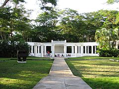 Quinta de San Pedro Alejandrino in Santa Marta
 -
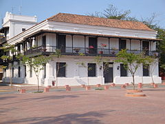 Casa de la Aduana
 -
 Statue of Rodrigo de Bastidas


-
 Rodadero, Santa Marta
 -
 Rodadero aquarium
 -
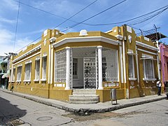 Traditional house in Santa Marta


-
 Lighthouse in the bay of Santa Marta
 -
 El Morro island off the coast of Santa Marta
 -
 Harbour of Santa Marta
 -


-
 The cathedral (inner view)
 -
 On central square
 -
 The cathedral


Notable people
- Sergio Díaz-Granados Guida, IDB Executive Director for Colombia and Peru
- Radamel Falcao, professional footballer
- Jesús Ferreira, professional footballer
- Maria Claudia Lacouture, executive director of the Colombo American Chamber of Commerce
- Alejandro Palacio, singer of vallenato music
- Arturo Reyes, football coach
- Aldo Leão Ramírez, professional footballer
- Li Saumet, vocalist of Bomba Estéreo band
- Andrés Solano, professional footballer
- Luis Javier Suárez, professional footballer
- Carlos Valderrama, professional footballer
- Antony de Ávila, professional footballer
- Taliana Vargas, actress and model
- Carlos Vives, singer of vallenato music
- Johan Vonlanthen, professional footballer
- Lalo Ebratt, Reggaeton singer
Media appearances
Santa Marta is the production location of the TV series The White Slave.
See also
References
- ^ "2018 census" (PDF). Departamento Administrativo Nacional de Estadística (DANE), Colombia (in Spanish). Retrieved 28 May 2022.
- ^ "Santa Marta Postal Codes". Retrieved 2017-08-31.
- ^ "Santa Marta historia y tradición" (in Spanish). Ministerio de Educación Nacional.
- ^ "Colombia" (in Spanish). Decameron. Archived from the original on 26 February 2009. Retrieved 28 May 2009.
- ^ "Promedios Climatológicos 1981–2010" (in Spanish). Instituto de Hidrologia Meteorologia y Estudios Ambientales. Archived from the original on 15 August 2016. Retrieved 16 August 2016.
- ^ "Promedios Climatológicos 1971–2000" (in Spanish). Instituto de Hidrologia Meteorologia y Estudios Ambientales. Archived from the original on 15 August 2016. Retrieved 16 August 2016.
- ^ "Tiempo y Clima" (in Spanish). Instituto de Hidrologia Meteorologia y Estudios Ambientales. Archived from the original on 15 August 2016. Retrieved 16 August 2016.
- ^ "Promedios Climatológicos 1981–2010" (in Spanish). Instituto de Hidrologia Meteorologia y Estudios Ambientales. Archived from the original on 15 August 2016. Retrieved 17 June 2024.
- ^ "Promedios Climatológicos 1981–2010" (in Spanish). Instituto de Hidrologia Meteorologia y Estudios Ambientales. Archived from the original on 15 August 2016. Retrieved 17 June 2024.
- ^ "Promedios Climatológicos 1981–2010" (in Spanish). Instituto de Hidrologia Meteorologia y Estudios Ambientales. Archived from the original on 15 August 2016. Retrieved 17 June 2024.
External links
![]() Media related to Santa Marta at Wikimedia Commons
Media related to Santa Marta at Wikimedia Commons
- (in Spanish) UNIMAGDALENA
- (in Spanish) Bank of the Republic, economic history of Santa Marta
 Media related to Santa Marta at Wikimedia Commons
 Santa Marta travel guide from Wikivoyage
- . New International Encyclopedia. 1905.
| International | |
|---|---|
| National | |
| Geographic | |
| Other | |

Recent Comments