
How Can We Help?

Size of this preview: 445 × 599 pixels. Other resolutions: 178 × 240 pixels | 356 × 480 pixels | 570 × 768 pixels | 760 × 1,024 pixels | 2,003 × 2,698 pixels.
Original file (2,003 × 2,698 pixels, file size: 2.19 MB, MIME type: image/jpeg)
Summary
| Description |
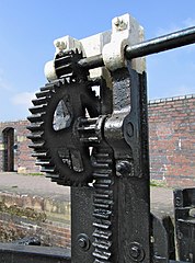
English: Lock gate cogs, Montgomery Canal This rack and pinion system is operated by a Windlass (a handle that canal boat users have with them).
At the moment some parts of the Montgomery Canal are not navigable. |
| Date | |
| Source | From geograph.org.uk |
| Author | Dave Croker |
| Attribution (required by the license) | Dave Croker / Lock gate cogs, Montgomery Canal / |
| Camera location | | View this and other nearby images on: OpenStreetMap |
|---|
| Object location | | View this and other nearby images on: OpenStreetMap |
|---|
Licensing

|
This image was taken from the Geograph project collection. See this photograph's page on the Geograph website for the photographer's contact details. The copyright on this image is owned by Dave Croker and is licensed for reuse under the Creative Commons Attribution-ShareAlike 2.0 license.
|
This file is licensed under the Creative Commons Attribution-Share Alike 2.0 Generic license.
Attribution: Dave Croker
- You are free:
- to share – to copy, distribute and transmit the work
- to remix – to adapt the work
- Under the following conditions:
- attribution – You must give appropriate credit, provide a link to the license, and indicate if changes were made. You may do so in any reasonable manner, but not in any way that suggests the licensor endorses you or your use.
- share alike – If you remix, transform, or build upon the material, you must distribute your contributions under the same or compatible license as the original.
File history
Click on a date/time to view the file as it appeared at that time.
| Date/Time | Thumbnail | Dimensions | User | Comment | |
|---|---|---|---|---|---|
| current | 14:18, 14 March 2011 | | 2,003 × 2,698 (2.19 MB) | GeographBot | == {{int:filedesc}} == {{Information |description={{en|1=Lock gate cogs, Montgomery Canal This rack and pinion system is operated by a Windlass (a handle that canal boat users have with them). At the moment some parts of the Montgomery Canal are not navi |
File usage
The following pages on the English Wikipedia use this file (pages on other projects are not listed):
Global file usage
The following other wikis use this file:
- Usage on ar.wikipedia.org
- Usage on ca.wikipedia.org
- Usage on es.wikipedia.org
- Usage on sv.wikipedia.org
- Usage on zh.wikipedia.org

_heading:292.00&language=en)
_heading:292.00&language=en)
Recent Comments