
How Can We Help?

Size of this preview: 800 × 434 pixels. Other resolutions: 320 × 174 pixels | 640 × 348 pixels | 1,024 × 556 pixels | 1,280 × 695 pixels | 2,560 × 1,390 pixels | 4,961 × 2,694 pixels.
Original file (4,961 × 2,694 pixels, file size: 11.19 MB, MIME type: image/jpeg)
Summary
| Description |
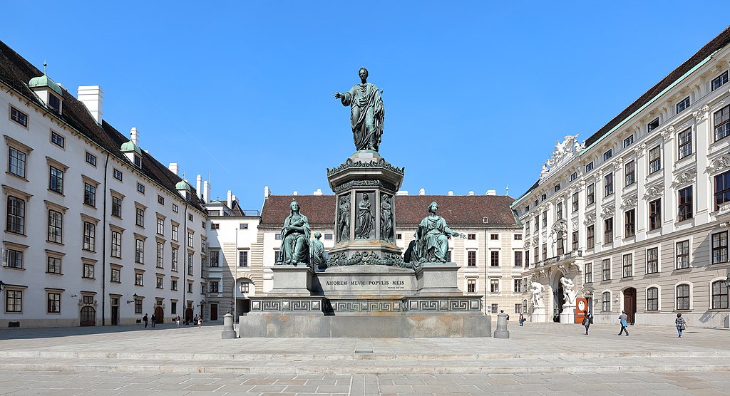
Deutsch: Das Denkmal Kaiser Franz I. (II.) am Inneren Burgplatz (In der Burg) der Hofburg in der österreichischen Bundeshauptstadt Wien. Links der Leopoldinischer Trakt, hinter dem Denkmal der Amalientrakt (Amalienburg) und rechts der Reichskanzleitrakt.
Das Monumentaldenkmal für den ersten österreichischen Kaiser und letzten des Heiligen Römischen Reiches Franz I. (II.) wurde auf Veranlassung von Kaiser Ferdinand I. von dem Bildhauer Pompeo Marchesi geschaffen und am 16. Juni 1846 enthüllt. Es stellt den Kaiser auf einem achteckigen Pfeiler in antiker Gewandung dar. An den Seitenfronten des Pfeilers sind bronzene Reliefs angebracht, die die Tätigkeiten des Volkes darstellen. Flankiert wird der Pfeiler von vier Kolossalstatuen, die den Glauben, die Stärke, den Frieden und die Gerechtigkeit symbolisieren.
|
|||
| Date | ||||
| Source | Own work | |||
| Author | C.Stadler/Bwag | |||
| Permission (Reusing this file) |
Deutsch: Hallo, du darfst mein Foto kostenlos nutzen, aber nenne mich bitte als Fotograf, beispielsweise „Foto: C.Stadler/Bwag“ oder © C.Stadler/Bwag; CC-BY-SA-4.0. Auf mehr Angaben bestehe ich nicht - im Gegensatz zu manch anderen, die die Vorgaben der unten angeführten Lizenzierung auf Punkt und Beistrich einfordern. English: Feel free to use my photos, but please mention me as the author like © C.Stadler/Bwag or © C.Stadler/Bwag; CC-BY-SA-4.0 (that's good enough) and if you want send me a message: bwag@gmx.net. |
|||
| Other versions |
|

.JPG)
| Camera location | | View this and other nearby images on: OpenStreetMap |
|---|
Licensing
I, the copyright holder of this work, hereby publish it under the following license:
This file is licensed under the Creative Commons Attribution-Share Alike 4.0 International license.
- You are free:
- to share – to copy, distribute and transmit the work
- to remix – to adapt the work
- Under the following conditions:
- attribution – You must give appropriate credit, provide a link to the license, and indicate if changes were made. You may do so in any reasonable manner, but not in any way that suggests the licensor endorses you or your use.
- share alike – If you remix, transform, or build upon the material, you must distribute your contributions under the same or compatible license as the original.
File history
Click on a date/time to view the file as it appeared at that time.
| Date/Time | Thumbnail | Dimensions | User | Comment | |
|---|---|---|---|---|---|
| current | 19:43, 1 October 2016 | | 4,961 × 2,694 (11.19 MB) | Bwag | {{Information |Description= {{de|1= Das Denkmal Kaiser Franz I. am Inneren Burgplatz (In der Burg) der Hofburg in der österreichischen Bundeshauptstadt Wien. Links der Leopoldinischer Trakt, hinter dem Denkmal der Amalien... |
File usage
The following pages on the English Wikipedia use this file (pages on other projects are not listed):
Global file usage
The following other wikis use this file:
- Usage on ar.wikipedia.org
- Usage on de.wikipedia.org

.JPG¶ms=048.207306_N_0016.365333_E_globe:Earth_type:camera_alt:180_source:exif_heading:315.00&language=en)
Recent Comments