
The New Guinea Portal
Introduction

New Guinea (Tok Pisin: Niugini; Hiri Motu: Niu Gini; Indonesian: Papua, fossilized Nugini, or historically Irian) is the world's second-largest island, with an area of 785,753 km2 (303,381 sq mi). Located in Melanesia in the southwestern Pacific Ocean, the island is separated from Australia by the 150-kilometre (81-nautical-mile; 93-mile) wide Torres Strait, though both landmasses lie on the same continental shelf, and were united during episodes of low sea level in the Pleistocene glaciations as the combined landmass of Sahul. Numerous smaller islands are located to the west and east. The island's name was given by Spanish explorer Yñigo Ortiz de Retez during his maritime expedition of 1545 due to the resemblance of the indigenous peoples of the island to those in the African region of Guinea. (Full article...)
Papua New Guinea, officially the Independent State of Papua New Guinea, is a country in Oceania that comprises the eastern half of the island of New Guinea and its offshore islands in Melanesia (a region of the southwestern Pacific Ocean north of Australia). It shares its only land border with Indonesia to the west and its other close neighbors are Australia to the south and the Solomon Islands to the east. Its capital, located on its southern coast, is Port Moresby. The country is the world's third largest island country, with an area of 462,840 km2 (178,700 sq mi). (Full article...)
Western New Guinea, also known as Papua, Indonesian New Guinea, and Indonesian Papua, is the western, formerly Dutch presently Indonesian, half of the island of New Guinea, granted to Indonesia in 1962. Given the island is alternatively named Papua, the region is also called West Papua (Indonesian: Papua Barat). (Full article...)
Selected article -
-

The New Guinea Volunteer Rifles (NGVR) was an infantry battalion of the Australian Army. It was initially raised as a unit of the Militia from white Australian and European expatriates in New Guinea upon the outbreak of the Second World War in 1939, before being activated for full-time service following the Japanese landings in early 1942. NGVR personnel then helped rescue survivors of Lark Force from Rabaul in February and March 1942. Between March and May, the NGVR monitored the Japanese bases which had been established in the Huon Gulf region, being the only Allied force in the area until the arrival of Kanga Force at Wau in May. The battalion subsequently established observation posts overlooking the main approaches and reported on Japanese movements.
Later, it inflicted significant casualties on the Japanese in a series of raids, and led them to believe that they faced a much larger opposing force. On 29 June, the NGVR and the newly arrived 2/5th Independent Company carried out a highly successful attack on the Japanese garrison in Salamaua, killing at least 113 men. When the focus shifted to the Milne Bay and Kokoda Track battles of August and September, the NGVR continued to man its posts overlooking the Japanese base areas. The Japanese were subsequently defeated in the Battle of Wau in January and February 1943, relieving the pressure on the NGVR. The battalion was disbanded in April 1943 due to attrition.
In the years immediately following the war the Australian Army considered re-establishing a military presence in Papua New Guinea (PNG), although there was some opposition among white settlers to the raising of native units. As an interim measure, the re-establishment of the NGVR was approved in July 1949. The unit reformed as the Papua New Guinea Volunteer Rifles (PNGVR) on 16 March 1951, initially as a whites-only reserve unit of the Citizen Military Forces (CMF). In March 1951 a PNGVR detachment assisted in relief operations following the eruption of Mount Lamington, which killed 3,466 people and left more than 5,000 homeless. Between 1951 and 1953 PNGVR elements were established in all the main centres of Papua New Guinea. (Full article...) -
Bougainville, an autonomous region of Papua New Guinea (PNG), has been inhabited by humans for at least 29,000 years, according to artefacts found in Kilu Cave on Buka Island. The region is named after Bougainville Island, the largest island of the Solomon Islands archipelago, but also contains a number of smaller islands.
The first arrivals in Bougainville were ethnically Australo-Melanesian, related to Papuans and Aboriginal Australians. Around 3,000 years ago, Austronesians associated with the Lapita culture also settled on the islands, bringing agriculture and pottery. Present-day Bougainvilleans are descended from a mixture of the two populations, and both Austronesian and non-Austronesian languages are spoken to this day.
In 1616, Dutch explorers Willem Schouten and Jacob Le Maire became the first Europeans to sight the islands. The main island was named after French admiral Louis Antoine de Bougainville, who reached it in 1768. The German Empire placed Bougainville under a protectorate in 1886, while the remainder of the Solomon Islands became part of the British Empire in 1893. The present-day boundaries between Papua New Guinea and Solomon Islands were established by the Tripartite Convention of 1899. The incorporation of Bougainville into German New Guinea initially had little economic impact, although the associated Catholic missions succeeded in converting a majority of the islanders to Christianity. (Full article...) -
Severe Tropical Cyclone Rewa affected six countries and caused 22 deaths on its 28-day journey across the South Pacific Ocean in December 1993 and January 1994. Cyclone Rewa developed from a tropical disturbance on 28 December south of Nauru. After forming, Rewa moved southwest through the Solomon Islands, crossing the 160th meridian east from the South Pacific basin into the Australian region. The cyclone began to strengthen steadily and turned southward, paralleling the eastern Australian coast through 31 December. Rewa reached its initial peak intensity as a Category 4 tropical cyclone on 2 January. It maintained this intensity for about 12 hours before an increase in wind shear induced its weakening by 3 January. The cyclone turned southeastward and moved back into the South Pacific basin on 4 January, before it passed over New Caledonia between 5–6 January. After affecting New Caledonia, Rewa weakened to a tropical depression and turned northwestward before re-entering the Australian basin on 10 January.
Over the following days, the cyclone showed signs of restrengthening and executed an elongated cyclonic loop to the southeast of Papua New Guinea. Rewa subsequently entered a phase of quick intensification while proceeding southeastward, peaking in intensity as a Category 5 severe tropical cyclone. It recurved toward the southwest while gradually weakening for several days. Although forecasters had predicted Rewa to make landfall near Mackay, Queensland, the cyclone began interacting with an upper-level trough on 18 January, causing it to divert to the southeast and move along the Queensland coast. Rewa transitioned into an extratropical cyclone on 20 January, with its remnants bringing heavy rain to New Zealand three days later.
The cyclone caused the deaths of 22 people on its course, affecting parts of the Solomon Islands, Papua New Guinea, Eastern Australia, New Caledonia, Vanuatu and New Zealand. Nine people in a banana dinghy en route to Rossel Island went missing at the height of the storm; they were presumed drowned after wreckage from their boat turned up at the island. In Queensland, three people died in traffic accidents caused by the storm, and another fatality occurred when a boy became trapped in a storm pipe. One death took place in New Caledonia, while flooding caused eight drownings in Papua New Guinea. Because of the severe impacts that Rewa brought, the name was retired. (Full article...) -
The Ok Tedi is a river in New Guinea. The Ok Tedi Mine is located near the headwaters of the river, which is sourced in the Star Mountains. It is the second largest tributary of the Fly River. Nearly the entirety of the river runs through the North Fly District of the Western Province of Papua New Guinea, but the river crosses the international boundary with Indonesia for less than one kilometre. The largest settlement of the Western Province, Tabubil is located near its banks. (Full article...) -
The disputed territory of West New Guinea
The West New Guinea dispute (1950–1962), also known as the West Irian dispute, was a diplomatic and political conflict between the Netherlands and Indonesia over the territory of Dutch New Guinea. While the Netherlands had ceded sovereignty over most of the Dutch East Indies to Indonesia on 27 December 1949 following an independence struggle, it retained control over its colony on the western half of New Guinea. The Indonesian government claimed this territory as well, on the basis that it had belonged to the Dutch East Indies and that the new Republic of Indonesia was the legitimate successor to the former Dutch colony.
During the first phase of the dispute (1950–1954), Indonesia pursued bilateral negotiations with the Netherlands. During the second phase (1954–1958), Indonesia attempted to raise support for its territorial claims in the United Nations General Assembly. During the third phase (1960–1962), Indonesia pursued a policy of confrontation against the Netherlands which combined diplomatic, political, and economic pressure with limited military force. The final stage of the confrontation with Indonesia also involved a planned military invasion of the territory. The Indonesians also secured military weapons and political and military support from the Soviet Union, which induced the United States to intervene in the conflict as a third-party mediator between Indonesia and the Netherlands. Following the New York Agreement on 15 August 1962, the Netherlands, under U.S. pressure, handed West New Guinea over to a United Nations Temporary Executive Authority, which subsequently handed the territory over to Indonesia on 1 May 1963. Following a controversial plebiscite in 1969, West New Guinea was formally integrated into Indonesia. (Full article...) -
Raja Ampat, or the Four Kings, is an archipelago located off of the northwest tip of Bird's Head Peninsula (on the island of New Guinea), Southwest Papua province, Indonesia. It comprises over 1,500 small islands, cays, and shoals around the four main islands of Misool, Salawati, Batanta, and Waigeo, and the smaller island of Kofiau.
The Raja Ampat archipelago straddles the equator and forms part of the Coral Triangle, an area of Southeast Asian seas containing the richest marine biodiversity on earth. The Coral Triangle itself is an approximate area west-southwest of the Philippines, east-northeast and southeast of the island of Borneo, and north, east and west of the island of New Guinea, including the seas in between. Thousands of species of marine organisms, from the tiniest cleaner shrimp and camouflaged pygmy seahorses to the majestic cetaceans and whale sharks, thrive in these waters.
Administratively, the archipelago is part of the province of Southwest Papua. Most of the islands constitute the Raja Ampat Regency, which was separated from Sorong Regency in 2004. The regency encompasses around 70,000 square kilometres (27,000 sq mi) of land and sea, of which 8,034.44 km2 constitutes the land area and has a population of 64,141 at the 2020 Census; the official estimate as at mid 2022 was 66,839. This excludes the southern half of Salawati Island, which is not part of this regency but instead constitutes the Salawati Selatan and Salawati Tengah Districts of Sorong Regency. (Full article...) -
The Mamberamo Lakes Plains (Dutch Meervlakte, Malay dataran danau-danau) are a large, flat low-lying area of the Mamberamo River basin in the Indonesian province Papua on the island of New Guinea. The plain is defined by the meandering tributaries of the Mamberamo, and includes hundreds of oxbow lakes. It is 300 kilometers long and about 50 kilometers wide, and is entirely enclosed by mountains apart from the outlet of the Mameramo.
It is inhabited in the west, but the eastern lobe is largely uninhabited. (Full article...) -
Daru Island is an island in the Western Province of Papua New Guinea. It is one of the Torres Strait Islands. The eponymous town on the island is the capital of the province, and houses the vast majority of the island's population of 20,524 (2009). Daru Island is elliptical in shape, with dimensions of 5.0 by 3.7 kilometers, an area of 14.7 km2, and an elevation of up to 27 m. The island is separated from the mainland in the north, specifically the mouth of Oriomo River, by the 3.5 km wide Daru Roads. The shortest distance to the larger Bristow Island (also called Bobo Island) in the south is 1.3 km.
Daru Island is one of the few Torres Strait Islands that do not belong to Australia, but to Papua New Guinea. It is also the most highly populated of the Torres Strait Islands, although scarcely any original Torres Strait Islanders live on the island. The main industry on the island is fishing although few fisheries are locally owned. The island has an international airport which is mainly used by Australian aircraft chartered by mining companies for customs clearance or to pick up jet fuel. Commercial flights service Daru Airport four days per week. (Full article...) -
Sir William Jack Skate KCMG (26 September 1953 – 3 January 2006) was a prominent Papua New Guinea politician. He was the son of an Australian father and a Papua New Guinean mother. Though his career was turbulent and often marked by setbacks, he served in the highest posts in his country: prime minister of Papua New Guinea, speaker of the National Parliament, and as acting governor-general of Papua New Guinea. (Full article...)
-
The Nduga massacre (Indonesian: Pembantaian Nduga) was a shooting of construction workers that occurred on 1 December 2018, in Nduga Regency, Papua (now in Highland Papua), Indonesia. The shooting is considered to be part of the Papuan conflict. The West Papua National Liberation Army (TPNPB) acknowledged responsibility and the Indonesian government labeled the attack a massacre. (Full article...)
-

The yellow-bellied sheath-tailed bat (Saccolaimus flaviventris), also known as the yellow-bellied sheathtail or yellow-bellied pouched bat, is a microbat species of the family Emballonuridae found extensively in Australia and less commonly in parts of Papua New Guinea.
Although found throughout most parts of Australia, very little is known about its ecology due to the small size, nocturnal activity, and general elusiveness of most microbat species, making them difficult to study. They are sometimes mistaken for the endangered and less widely distributed bare-rumped sheathtail bat where the two species occur sympatrically, as well as other similar Emballonuridae species, but upon inspection are quite distinct and easily identified.
At present, the yellow-bellied sheath-tailed bat is the only member of the Microchiroptera that has been positively identified as a carrier of Australian bat lyssavirus. (Full article...) -

Greater bird-of-paradise
The fauna of New Guinea comprises a large number of species of mammals, reptiles, birds, fish, invertebrates and amphibians.
As the world's largest and highest tropical island, New Guinea occupies less than 0.5% of world's land surface, yet supports a high percentage of global biodiversity. Approximately 4,624 vertebrate species inhabit the island of New Guinea and its surrounding waters, which constitutes about 8% of the recognized world vertebrates. This ranges from an estimated 4% of the world's lizards and mammals, to about 10% of the world's fish species.
The numbers of global and New Guinea invertebrate species are poorly known, and thus an accurate comparison is difficult. Butterflies are the best known invertebrate group, and are represented in New Guinea by about 735 species, which is about 4.2% of the world total of 17,500 species. (Full article...) -
The Sepik (/ˈsɛpɪk/) is the longest river on the island of New Guinea, and the second largest in Oceania by discharge volume after the Fly River. The majority of the river flows through the Papua New Guinea (PNG) provinces of Sandaun (formerly West Sepik) and East Sepik, with a small section flowing through the Indonesian province of Papua.
The Sepik has a large catchment area, and landforms that include swamplands, tropical rainforests and mountains. Biologically, the river system is often said to be possibly the largest uncontaminated freshwater wetland system in the Asia-Pacific region. But, in fact, numerous fish and plant species have been introduced into the Sepik since the mid-20th century. (Full article...) -
The Kaluli creation myth is a traditional creation myth of the Kaluli people of Papua New Guinea. In the version as was recorded by anthropologist and ethnographer Edward L. Shieffelin whose first contact with them took place in the late 1960s. The story begins in a time the Kaluli call hena madaliaki, which translates "when the land came into form." During the time of hena madaliaki people covered the earth but there was nothing else: no trees or plants, no animals, and no streams. With nothing to use for food or shelter, the people became cold and hungry. Then one man among them (alternative accounts give two) gathered everyone together and delegated different tasks. He directed one group to become trees and they did. He directed another to become sago, yet another to be fish, another banana and so forth until the world was brimming with animals, food, streams, mountains and all other natural features. There were only a few people left and they became the ancestors of present-day human beings.
The Kaluli describe this story as "the time when everything alə bano ane" which means roughly "the time when everything divided". This concept of all world phenomena as a result of a "splitting" has many echos in Kaluli thought and cultural practices. In the Kaluli world view, all of existence is made from people who differentiated into different forms. Animals, plants, streams and people are all the same except in the form they have assumed following this great split. Death is another splitting. The Kaluli have no concept of a transcendent, sacred domain that is spiritual or in any fundamental way distinct from the natural, material world; instead death is another event that divides beings through the acquisition of new forms which are unrecognizable to the living.
The Kaluli are an indigenous people whose first contact with contemporary western civilization began in the 1940s. Following extensive Christian missionary efforts in the region, variants of the traditional creation story have adopted a few Christian elements. Prior to contact, the Kaluli story described creation as a pragmatic solution to problems of cold and hunger, and the efforts were initiated by one or two ordinary and unnamed men rather than any deity or deities. The Kaluli have since tended to identify one or both of them as "Godeyo" (God) and "Yesu" (Jesus Christ). (Full article...) -

The Papua conflict (Indonesian: Konflik Papua) is an ongoing conflict in Western New Guinea (Papua) between Indonesia and the Free Papua Movement (Indonesian: Organisasi Papua Merdeka, OPM). Subsequent to the withdrawal of the Dutch administration from the Netherlands New Guinea in 1962 and implementation of Indonesian administration in 1963, the Free Papua Movement has conducted a low-intensity guerrilla war against Indonesia through the targeting of its military, police, as well as civilian populations.
Papuan separatists have conducted protests and ceremonies, raising their flag for independence or calling for federation with Papua New Guinea, and accuse the Indonesian government of indiscriminate violence and of suppressing their freedom of expression. Indonesia has also been accused of conducting a genocidal campaign against the indigenous inhabitants. In a 2007 book, author De R. G. Crocombe wrote that an estimated 100,000 to 300,000 Papuans had been killed by Indonesian security forces, and many women raped or subjected to other sexual violence. Research on violence toward Papuan women by the Papuan Women's Working Group, together with the Asia Justice Rights (AJAR), found that 64 out of 170 (or 4 out of 10) Papuan women surveyed in 2013, 2017 experienced some form of state violence. A more recent study in 2019 found that 65 out of 249 Papuan women shared such experiences. The UN has called for "urgent and unrestricted humanitarian aid to the region" in 2022, speaking of "shocking abuses" against local populations listing "child killings, disappearances, torture and mass population displacement."
Indonesian governance in the region has been compared to that of a police state, involving the suppression of free political association and expression, although others have noted conflicts in Papua are instead caused by the near or total absence of state involvement in some areas. (Full article...)


Did you know (auto-generated)

- ... that Australiformis semoni is a parasite that infests marsupials in Australia and New Guinea and whose infestation could cause debilitating ulcerative granulomatous gastritis?
- ... that Australian official Jack Emanuel was awarded the George Cross in 1971 after being stabbed to death whilst trying to resolve a land dispute with the Tolai people of New Guinea?
- ... that David Dexter, who wrote the New Guinea volume in the series Australia in the War of 1939–1945, was a commando who served in East Timor and New Guinea?
- ... that Dorkas Tokoro-Hanasbey, the only female member of the New Guinea Council, arrived thirty minutes late to her inauguration ceremony?
- ... that until Rufina Peter and Kessy Sawang's election in August 2022, Papua New Guinea was one of only three countries without a woman in parliament?
- ... that the clinical trials of British scientist Peter Pharoah helped eradicate congenital iodine deficiency syndrome (cretinism) in Papua New Guinea?
General images -
-
 New Guinea crocodile (from New Guinea)
 -
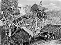
 Hoisting the German flag at Mioko in 1884 (from History of Papua New Guinea)
 -
 Group of natives at Mairy Pass. Mainland of British New Guinea in 1885. (from New Guinea)
 -
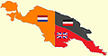 New Guinea from 1884 to 1919. The Netherlands controlled the western half of New Guinea, Germany the north-eastern part, and Britain the south-eastern part. (from New Guinea)
 -
 Political divisions of New Guinea (2006) (from New Guinea)
 -
 Coral reefs in Papua New Guinea (from New Guinea)
 -
 New Guinea Volunteer Rifles with captured Japanese flag, 1942 (from History of Papua New Guinea)
 -
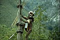
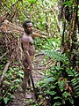 Korowai tribesman (from New Guinea)
 -
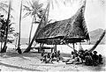
 Koiari village near Bootless Inlet, British New Guinea (from History of Papua New Guinea)
 -

-
 Regions of Oceania: Australasia, Polynesia, Micronesia, and Melanesia. Physiographically, Australasia includes the Australian landmass (including Tasmania), New Zealand, and New Guinea (from New Guinea)
 -
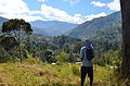 Highlands of Papua New Guinea (from New Guinea)
 -
 Western New Guinea was formally annexed by Indonesia in 1969. (from New Guinea)
 -
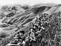 Australian soldiers resting in the Finisterre Ranges of New Guinea while en route to the front line (from New Guinea)
 -
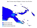 Papua New Guinea map of Köppen climate classification (from New Guinea)
 -
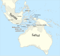 The continent of Sahul before the rising ocean sundered Australia and New Guinea after the last ice age (from New Guinea)
 -
 Mount Bosavi (from New Guinea)
 -
 Map of New Guinea, with place names as used in English in the 1940s (from New Guinea)
 -
 An Australian soldier, Private George "Dick" Whittington, is aided by Papuan orderly Raphael Oimbari, near Buna on 25 December 1942. (from History of Papua New Guinea)
 -
Map showing the combined landmass of Sahul formed during Pleistocene glacations (from New Guinea)
-
 A Japanese military map of New Guinea from 1943 (from New Guinea)
 -

-
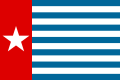 The Morning Star, flag of West Papua, was designed by the New Guinea Council in 1961. Its display is prohibited in some circumstances in Indonesia. (from History of Western New Guinea)
 -
 Papuans on the Lorentz River, photographed during the third South New Guinea expedition in 1912–13 (from New Guinea)
 -
 Dutch expeditions in Netherlands New Guinea 1907–1915. (from History of Western New Guinea)
 -
Regions of Oceania: Australasia, Polynesia, Micronesia, and Melanesia. Australasia include the Australian landmass (including Tasmania), New Zealand, and New Guinea. (from History of Papua New Guinea)
-
 Australian troops at Milne Bay, Papua.The Australian garrison was the first to inflict defeat on the Imperial Japanese Army during World War II at the Battle of Milne Bay of Aug–Sep 1942. (from History of Papua New Guinea)
 -
 The raggiana bird-of-paradise is native to New Guinea. (from New Guinea)
 -
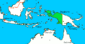
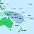 New Guinea located in relation to Melanesia (from New Guinea)
 -
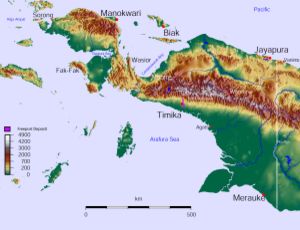
 Topographical map of New Guinea (from New Guinea)
 -

-
 The floristic region of Malesia (from New Guinea)
 -
 British flag raised in Queensland 1883 (from History of Papua New Guinea)
 -
 A 1644 map of New Guinea and the surrounding area (from New Guinea)
 -
A typical map from the Golden Age of Netherlandish cartography. Australasia during the Golden Age of Dutch exploration and discovery (ca. 1590s–1720s): including Nova Guinea (New Guinea), Nova Hollandia (mainland Australia), Van Diemen's Land (Tasmania), and Nova Zeelandia (New Zealand). (from History of Papua New Guinea)
-
 Yali Mabel, Kurulu Village War Chief at Baliem Valley (from New Guinea)
 -
 Flag under German control of New Guinea. (from History of Papua New Guinea)


Related portals
In the news
- 27 May 2024 – 2024 Enga landslide
- Papua New Guinea asks for international help following the landslide in Enga Province three days ago, and reports that more than 2,000 people were buried alive and are now presumed deceased. (AP)
- 26 May 2024 – 2024 Enga landslide
- The International Organization for Migration estimates that more than 670 people were killed in the landslide in Enga Province, Papua New Guinea, on Friday. (AP)
- 24 May 2024 – 2024 Enga landslide
- Four people are confirmed killed and many others are presumed dead in a landslide in Enga Province, Papua New Guinea. (Papua New Guinea Post-Courier) (RNZ)
WikiProjects
General topics
Categories

Associated Wikimedia
The following Wikimedia Foundation sister projects provide more on this subject:
-
 Commons
Free media repository -
 Wikibooks
Free textbooks and manuals -
 Wikidata
Free knowledge base -
 Wikinews
Free-content news -
 Wikiquote
Collection of quotations -
 Wikisource
Free-content library -
 Wikiversity
Free learning tools -
 Wiktionary
Dictionary and thesaurus
External media

More portals


Purge server cache

Recent Comments